BACK TO RESEARCH WITH IMPACT: FNR HIGHLIGHTS

The FNR Science Image Competition aims to show the beauty of research and science outreach in Luxembourg. LISER’s Karolina Zieba-Kulawik ‘dead trees’ is one of the awarded images in the 2022 Object of Study category. Learn more about this image and the research connected to it.

This image shows the colour-infrared aerial imagery of a forest in Luxembourg. This technique shows live vegetation in different shades of red. Vibrant red indicates healthy vegetation while dead trees glow in a turquoise colour.
Researchers such as Karolina Zieba-Kulawik – a research analyst in LISER’s Urban Development & Mobility Department – use this information to automatically detect dead trees, helping them provide maps to monitor vegetation changes nationwide. The problem of tree dieback (death of peripheral parts) is visible in the forests of Luxembourg. Spruces are especially affected and are now infested by insects. In March 2022, Luxembourg’s Nature and Forest Administration concluded that the majority of trees in Luxembourg are facing serious issues.
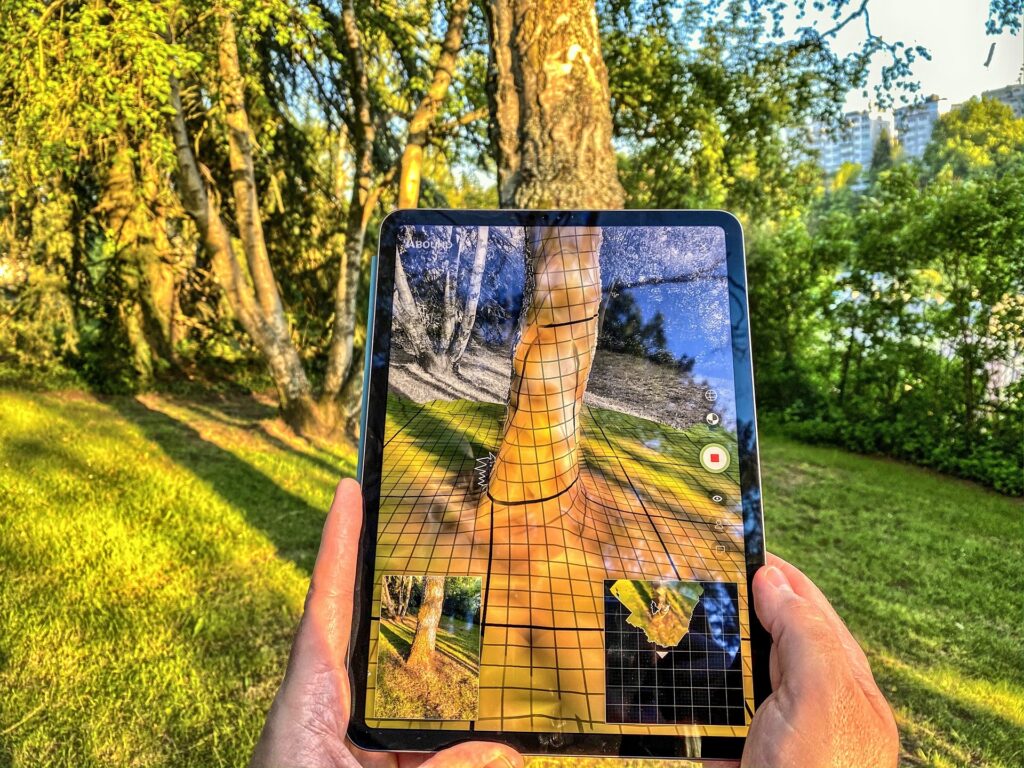
Could augmented reality facilitate urban forest inventories?
Colour-infrared aerial imagery is not the only method up researchers’ sleeves in the quest for better ways to gather more precise data from forest inventories – they have also turned to augmented reality. The image below shows a test of the reliability of a laser scanner application attached to an iPad Pro for perimeter at breast height and tree position estimations. These are two of the main variables collected during urban forest inventories.
Using heatmaps to monitor impact on greenery

The image shows the generated Land Surface Temperature (LST) information for Luxembourg City based on satellite imagery during one of the warmer and cloudless days of the year.
LST indicates how hot the ‘surface’ of the Earth would feel to the touch in a particular location. The temperatures in this picture range from 27°C (purple) to 45°C (yellow). The coolest areas in the city are the forests and valleys, such as the ‘Polvermillen’ or the ‘Pafendall’, whereas the urban zones are mostly hot spots. The map was made using data collected by Operational Land Imager and Thermal Infrared Sensor on the Landsat 8 satellite (NASA, USGS) and LiDAR point clouds (data.public.lu). Karolina Zięba-Kulawik, in cooperation with Konrad Skoczylas from the Luxembourg Institute of Socio-Economic Research (LISER), uses them in research on the monitoring and impact of greenery on the urban environment using spatial indices.
About the FNR Science Image Competition – discover the exhibition!

The FNR Science Image Competition ran for the first time in 2020, on the occasion of the FNR’s 20th birthday. Now in its third edition, the 2022 awarded and ‘distinction’ images – along with the ‘Prix du Public’ awarded in collaboration with media partner RTL, can be discovered at an exhibition at the Luxembourg Science Center from 29 June until the end of September 2022. From Mid-September 2022 you can also discover the exhibition in front of Lycée de Garçons in Luxembourg-Limpertsberg (Place Auguste Laurent) – until the end of the year.
Categories in the FNR Science Image Competition
1) Object of study: From the microcosm to the macrocosm, images of the research object captured by scientists using a camera or generated by a computer.
2) Scientists in action: Photographs of research in practice, presented by and featuring those conducting it.
3) Places and tools: Photographs of the surroundings in which scientists take measurements, generate data, share their passion, make discoveries and of the instruments they use while doing so.
4) Science outreach activities: Photographs of an activity where researcher and science communicators dialogue with the school children, students or the wider public or of interactive projects for school children, students and the wider public, giving them an overview of science and research and/or scientists’ research methods.


Discover the stories behind more images from the 2022 FNR Science Image Competition
WORD FROM THE JURY
An international jury selected the winning photographs, images and videos, based on their aesthetic quality and their aptitude to inspire and fascinate, to convey or to illustrate knowledge, to narrate a story, to engage the public to explore a new universe.
The aesthetic of this picture – the lines and colours – first drew the attention of the jury. A further reading of the photo makes it even more interesting: what at first glance looks like organic material viewed through the focal point of a microscope turns out to be an aerial view of trees. This aerial imagery technology does not only record nice pictures but can be a strategic tool for preserving our forests and biodiversity in general.