BACK TO RESEARCH WITH IMPACT: FNR HIGHLIGHTS
BACK TO RESEARCH WITH IMPACT: FNR HIGHLIGHTS

Ramona Pelich uses data from satellites in space to improve maritime surveillance and flood hazard monitoring. Splitting her time between the Luxembourg Institute of Science and Technology (LIST) and the company LuxSpace as part of her AFR-PPP Postdoc, the Romanian national’s work has already found direct application when flood maps she co-developed were used in the aftermath of destructive 2017 hurricanes Harvey and Irma.
“I have always been a curious person eager to learn new things and to address challenging problems for which I could propose different solutions. I find that research gives me the possibility to continue being curious about challenging scientific questions,” explains Ramona Pelich.
Ramona is currently funded by a Postdoc grant from the FNR’s AFR-PPP programme (now called Industrial Fellowships), which sees her work on a research collaboration between the Luxembourg Institute of Science and Technology (LIST) and industry partner LuxSpace.
Using data from space to monitor Earth
Ramona’s primary research goals revolve around the use of Earth Observation (EO) data for the improvement of maritime surveillance and flood hazard monitoring applications. Her current goals are directed towards today’s research challenges: characterization of floods in urban areas, estimation of vessel’s velocities, etc.
“I am passionate about the satellites orbiting around the world collecting interesting data”, Ramona says, elaborating:
“I work on interpreting spatially and temporally distributed radar signatures from different parts of the world. My goal is to use this knowledge to develop innovative applications addressing societal challenges at global scale. Examples of such applications are near real-time detection of floods and vessels using data streams generated by the Copernicus mission of the European Space Agency (ESA).”
Working with various types of Earth monitoring data acquired through space sensors, Ramona uses information processing techniques she acquired during her Engineering and PhD studies to make sense of the data.
Flood maps with a direct impact
Ramona points out that one part of her work that she thoroughly enjoys is seeing her work have an impact. One example of this is the flood maps she developed with colleagues at LIST – flood maps that found direct application during recent hurricanes Harvey and Irma on the American continent.
“We were able to provide the emergency responders in the US with detailed flood maps using our newly developed application on the European Space Agency’s Grid Processing On Demand (GPOD) platform. The activities of our LIST team were reported in a series of newspaper articles, TV and radio programs.”
The ‘flood maps’ are based on a change detection algorithm applied to radar images. Ramona explains the service allows for an efficient and reliable extraction of floodwater areas from space-borne imagery. Newly acquired images are uploaded to the GPOD immediately, enabling rapid mapping of the flooded areas that supports an emergency response.
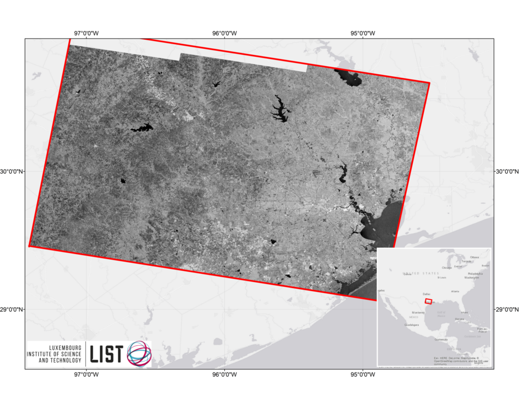
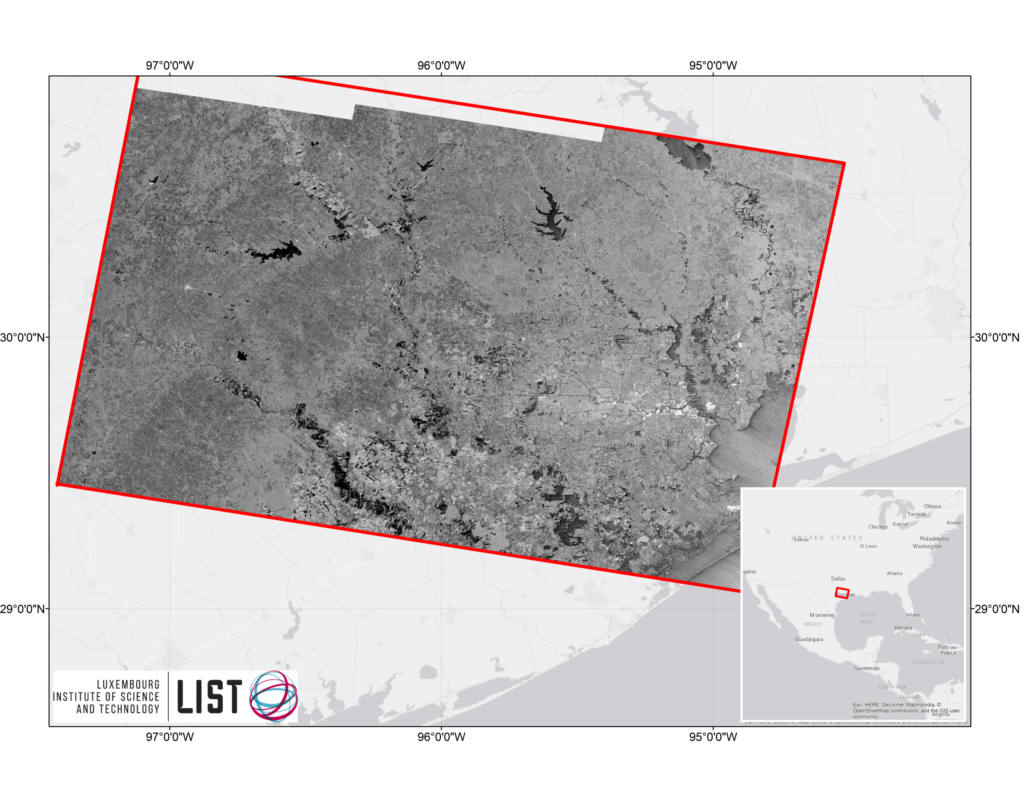
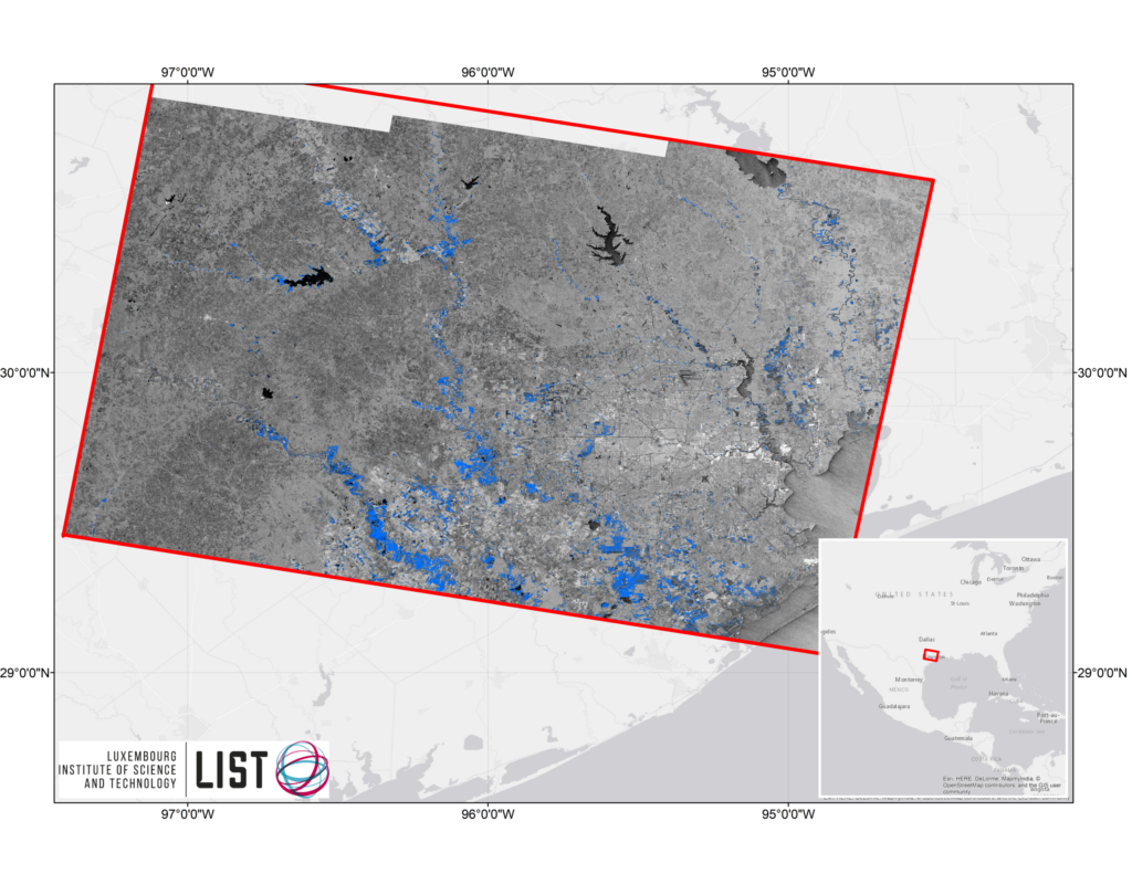
Detailed flood map over the Houston areas that were affected during the Harvey Hurricane. Sentinel-1 images provided under the COPERNICUS programme by the European Union and ESA.
“This is a unique opportunity to develop new applications making use of this infrastructure and bring them to the market in close collaboration with local industry.”
Exciting times are ahead for research in Luxembourg involving space and research using space born data – and for research collaborations between industry and research. Ramona points out that Luxembourg in 2017 signed a collaboration agreement with the European Space Agency (ESA), with the objective to establish the Luxembourg Sentinel Collaborative Ground Segment (LUCollGS) that will allow Luxembourg privileged access to the Earth Observation Data from the ESA.
“I am among the first recipients of an AFR-PPP grant for a project that assesses maritime surveillance with Sentinel-1 data. My experience in carrying out research both at a Research and Technology Organization (RTO), LIST, and a private company, LuxSpace, is ideally placed in the framework of LUCollGS.
“This is a unique opportunity to develop new applications making use of this infrastructure and bring them to the market in close collaboration with local industry. I believe that such collaborations will perpetuate since both the research labs and private companies can benefit from joint projects.”
Ramona explains that collaborating with an industry partner allows her to have a vision from an industrial point of view with respect to the maritime surveillance domain:
“Moreover, Luxembourg is actively involved in the maritime surveillance domain, for instance through its Commissariat aux Affaires Maritimes (CAM), which has shown an interest in my AFR-PPP project.”

“I think a very important part of a researcher’s career is the work with master and PhD students”
Having already seen her work find a direct implication with the use of the flood maps during the recent Hurricanes, Ramona explains that the best achievement for her research career would be to make a major contribution to a novel research application with a benefit for both society and the environment. A first step in this direction is the current AFR-PPP grant, which Ramona explains she was awarded due to the expertise in maritime surveillance domain she acquired during her PhD studies conducted at Télécom Bretagne and Collecte Localisation Satellites (CLS) in France.
“In my future career years, I aim to bring together all my knowledge and expertise into innovative and challenging research projects. I have a keen interest for the maritime surveillance domain and I aim at proposing new solutions based on EO data allowing to decrease, for example, the illegal fishing and maritime piracy.
“In addition to this, I am very eager to transmit my knowledge to people starting to work in the remote sensing and image processing domains. To this end, I think a very important part of researcher’s career is the work with master and PhD students. I hope that in the future years I will be able to transmit my know-how to the new generation and also be able to guide their career steps.”
